New “Water Book” outlines Arizona’s path forward on water

The Governor’s Office has released “Securing Arizona’s Water Future,” an illustrated outline of Governor Ducey’s plan for taking action to help secure the State’s water supplies.

The “water book,” as it is known, is available on the Governor’s website.

It escorts readers through Arizona’s storied (and, often, trailblazing) history of water management, including a candid outline of the challenges now facing the State in this era of drought. It also proposes legislative solutions to those issues.

Arizona is a renowned leader in water management thanks to its long history of careful planning and effective governance. But, with the State facing serious challenges to some of its key water supplies, the Governor’s Office asserts that the time to act on water policy is now.

Governor Ducey has prioritized Arizona’s water future as one of the most crucial policy issues facing the State. He highlighted the issue in his 2018 State of the State address:

“Earning Arizona’s reputation as a national leader in water management was no easy feat and it didn’t happen by accident. It was the proactive nature of our predecessors, and our state’s willingness to take-on complex issues.

“This session, we must follow their lead and put forward responsible policies that will ensure Arizona speaks with one-voice to secure the state’s future for generations to come.”

As the water book illustrates, Arizona relies on the Colorado River for 40 percent of its water supply. Unfortunately, the Colorado River system has experienced severe drought conditions for more than 17 years. Lake Mead, a vital reservoir on the Colorado River, is less than 40 percent full.

Lake Mead water levels are important because they determine whether a shortage is declared in the State’s Colorado River allocation, which would result in decreased delivery levels of water.

Based on data from the Bureau of Reclamation, the threat of a shortage declaration by the Bureau at Lake Mead is real.

Building on Arizona’s history of responsible initiatives, the Governor’s Office has proposed a plan that focuses on strategic conservation.

The plan also calls for protecting consumers through responsible groundwater management and by speaking with one voice on water-management issues, particularly regarding the Colorado River.

Governor Ducey’s plan would better enable voluntary conservation of Colorado River water by providing the State with forbearance authority relating to specified circumstances. This would contribute to higher Lake Mead elevations, reducing the likelihood of a shortage and providing increased protection from the economic consequences of water-delivery reductions.

With an eye toward achieving the management goals of Active Management Areas (the geographic areas created through Arizona’s landmark 1980 Groundwater Management Act), the Governor’s proposal would also establish an advisory committee to monitor the progress of AMAs.

Finally, since decisions about Arizona’s water supply affect the entire state, the Governor’s plan ensures accountability by requiring State authorization before entering into interstate deals involving Colorado River water.

Attack of the Blob: How an enormous, persistent arctic low-pressure system is helping dry out the American Southwest

Article_banner_1

It’s… the blob. It came from above. And it’s got the world in its grip.

And… it’s not going anywhere any time soon.

If that sounds like a trailer line for a low-budget sci-fi movie… well, it could be.

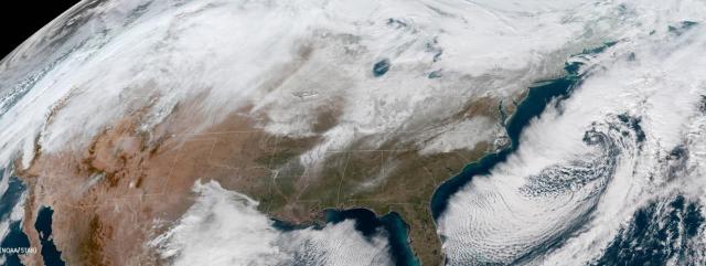
But it also fairly describes the powerful “Strong Hudson Bay Low” – an Arctic-spawned low-pressure systemthat locked in place over much of the Northern Hemisphere in mid-November. The strong, static “blocking” system is showing no sign of releasing its grip any time in the foreseeable future.

“WITH SNOW CONDITIONS IN THE UPPER COLORADO RIVER BASIN TRACKING AT JUST 31 PERCENT OF THE TOTAL AVERAGE SEASONAL ACCUMULATION AS OF MID-JANUARY, THE 2018 SEASON IS LOOKING DRYER THAN THE RECORD-DRY 2002 SEASON.”

And neither is one of the stronger regional effects of the huge low-pressure system:

An equally persistent, equally strong high-pressure ridge has locked into place beneath the blob. It sits in an equally unyielding “blocking” pattern over the eastern Pacific and the southwestern U.S., which is driving the west-east jet stream and its storms well to the north of the parched American Southwest.

That strong high-pressure system is proving to be a virtual mirror image of the Strong Hudson Bay Low, driving temperatures dramatically up and sapping the atmosphere of moisture.

“How strong and permanent it becomes depends on establishment of other high- and low-pressure systems as well as the amplitude of the jet stream around the globe,” explained Greg Smith, a senior hydrologist at the Colorado Basin River Forecast Center, a division of the National Weather Service and the National Oceanic and Atmospheric Administration.

Coming at the time of year when the western slopes of the Rocky Mountains typically build snowpack that, come spring, provides run-off into the Colorado River system, the moisture-robbing effects of this static high-pressure system may prove to be record-setting.

So too might the effects of the Artic blob.

On January 2 in the U.S., at least one location in all 50 states recorded temperatures below freezing. Yes, even in Hawaii.

Water fountains in Florida froze over. Off-shore, sharks swimming near Cape Cod froze to death. And all that occurred before the infamous “bomb cyclone” drove temperatures deeply negative on the entire East Coast for nearly a week.

On the opposite side of the globe, meanwhile, it’s the same deal. The Arctic blob has much of the eastern side of the Northern Hemisphere frozen and snow-bound, too.

In Yakutia, Siberia – 3,300 miles east of Moscow – residents reported their eyelashes freezing as temperatures dropped to an astonishing 88 degrees below zero Fahrenheit. In southwestern Scotland — typically cold and wet in the winter — blizzard conditions shut down highways. And shipping on the normally blue Danube – for now, icy gray – was halted because of ice.

All weather patterns being inter-related with all other weather patterns, the powerful high-pressure ridge sitting over much of the southwestern U.S. built up around the same time as the Strong Hudson Bay Low gathered its global steam – in mid-November.

And like its Hudson Bay “polar” opposite, there it has remained. And remained. Strong. Resolute. And dry.

While neither strong low-pressure systems that sweep down from the Arctic nor high-pressure ridges laying out over the western U.S. are unusual at this time of year, these systems are unique in one important respect: their persistence. They won’t quit.

The high-pressure ridge has proved so persistent – and the conditions it creates so dry – that hydrologists at the Forecast Center now are comparing this season’s snowpack in the Rockies (as well as in the Arizona mountains) to that of the infamously dry winter of 1976-1977, which produced one of the lowest inflows into Lake Powell on the Colorado River system on record.

How low did that inflow go?

The fall-winter “water year” season that ended in 1977 produced an unregulated Colorado River inflow into Lake Powell of roughly 5.8 million acre-feet. That is almost three million acre-feet less than the average river flow into Powell since 2000, a period when much of the Southwest, including Arizona, has been locked in chronic drought.

Measured against the historic average since 1964, the 1977 inflow into Powell was almost five million acre-feet below average. Since 1964, only three seasons have provided less runoff than 1977.

“What drew us to the comparison (with 1977) initially was the snow situation,” said Smith.

The Forecast Center’s highly advanced “SNOTEL” (for “snow telemetry”) network indicated that many of the Colorado River Basin’s snowpack areas, especially in the southern regions, were experiencing the “lowest snow on record,” according to Smith.

To Smith and other hydrologists, the atmospheric patterns prompting the weak snowpack seemed familiar:

“Some of us recall how poor conditions were in 1976-77. Then we noticed these large atmospheric features — strong low in the east and ridge in the west — were similar.”

Added Smith: “These are not uncommon features from year to year. But in both 1976-1977 and this year they were fairly strong, and the jet stream flow in the atmosphere similarly had a high amplitude. These strong low- and high-pressure systems, known as blocking features, or a blocking pattern, can be quite stubborn.”

As it stood in mid-January, the estimate for unregulated inflow into Lake Powell from the western slopes of the Rockies indicated the lake would receive 6.75 million acre-feet of runoff, or 62 percent of the historic, 30-year average. Not good, obviously. But not historically bad.

That estimate may be changing, however. And not for the better.

The lowest Colorado River inflow into Powell ever recorded was about 2.3 million acre-feet in 2002.

With snow conditions in the Upper Colorado River basin tracking at just 31 percent of the total average seasonal accumulation as of mid-January, the 2018 Water Year season – at this point in time — is looking dryer than the record-dry 2002 season.

A “snapshot” chart recently released by the federal Bureau of Reclamation compares the current water-year snow conditions with Water Year 2002. As of January 17, which is 57 percent through the snow-accumulation season, snow conditions were tracking well below conditions in 2001-2002.

Caveats apply, certainly.

Weather changes. The “blocking” low- and high-pressure systems could weaken and dissipate. And we are still relatively early in the snow-accumulation season. The very dry mid-January snapshot of conditions could look very different by mid-February.

As Smith notes, the 1976-1977 pattern finally broke down in March 1977, ushering in a much wetter late-winter period, especially in the northern Colorado and Great Basins.

As our days of unnervingly pleasant sunshine and annoyingly dry, easy breezes drone on – and on – the prospects for matching (or, gulp, “besting”) the Great Colorado River Dribble of 2002 increase.

But, again, as the forecasters well know, weather changes. Even the extraordinarily dry winter of 1977 ended pretty wet.


Agenda for annual meeting of Colorado River water users is released

TB at CRWUA 2016

Water Resources Director Buschatzke, speaking during the keynote panel discussion at CRWUA 2016

Editor’s Note: As a service to our readers, the Arizona Department of Water Resources once again is providing a live blog of events as they occur at the Colorado River Water Users Association conferences in Las Vegas, Dec. 12-15.

When they say water is fluid, they’re not kidding. Even convocations assembled to  discuss water policy must remain fluid, especially when those discussions involve Colorado River water policy. Such is the rapidly evolving nature of the complex issues facing Colorado River water users.

Organizers of the Colorado River Water Users Association (CRWUA) annual conference have released the event’s agenda. But even as late as early December, the agenda is identified as “tentative” in order to accommodate potential changes in meeting planning.

Each year, water leaders from the Colorado River system states and the federal Bureau of Reclamation — as well as the system’s major water users, such as cities and agriculture — gather at CRWUA, sharing ideas about management of the most complex water system in the country, the Colorado River.

A focus of discussion among Colorado River states for the last several years has been drought contingency planning to protect and stabilize the river system, particularly Lake Mead, where water levels have drifted dangerously low in recent years.

Discussion about a “DCP,” or Drought Contingency Plan, is certain to play a central role this year as well.

It certainly will be one of the underlying themes of the Keynote Panel Discussion scheduled for Thursday, Dec. 14, entitled “A Ballet in the Making: Choreographing Issues Across the Basin.”

Arizona Department of Water Resources Director Tom Buschatzke will take part in that panel discussion, along with four other top Colorado River water-user executives. The panel will be moderated by Eric Kuhn, general manager of the Colorado River District for the State of Colorado.


Flake, McCain legislation would formalize a tribal-water settlement agreement six years in the making

US-Senate-Committee-on-Indian-Affairs

Arizona Department of Water Resources Director Tom Buschatzke will testify before a Senate Committee on Wednesday in support of a breakthrough agreement settling the Hualapai Tribe’s claim to water rights on the Colorado River as well as other water sources in Arizona.

The agreement is the result of long, complex negotiations that began in 2011.

Buschatzke is one of just five witnesses scheduled to testify on Wednesday before the U.S. Senate Committee on Indian Affairs.

Pending congressional approval of the deal, the Hualapai Tribe will become the 12th of Arizona’s 22 federally recognized Indian tribes to fully resolve its water-rights claims.

According to the terms of the  settlement, the Tribe would receive an annual allocation of 4,000 acre-feet of Colorado River water. The allocation will come from a volume of Colorado River water delivered by the Central Arizona Project that is designated for future Indian water rights settlements in the Arizona Water Settlements Act of 2004.

In addition, the agreement calls for the U.S. Bureau of Reclamation to plan, design and build a pipeline capable of delivering no less than 3,414 acre-feet per year from Diamond Creek on the Colorado River to the Tribe at Peach Springs, as well as to its Grand Canyon West tourist attraction. The legislation authorizes an appropriation of $134.5 million for construction of the pipeline, as well as additional funding for operating expenses.

Director Buschatzke is expected to affirm Arizona’s strong support for the settlement agreement, which constitutes a major step toward resolving the outstanding water-rights claims of Indian tribes throughout the State. The agreement also will provide the Tribe with a renewable source of water that will replace its current groundwater pumping.

The Senate Committee on Indian Affairs hearing is scheduled to begin at 12:30 pm (MST). The legislation, S. 1770, is sponsored by Arizona Sens. Jeff Flake and John McCain. The Hualapai Tribe Water Rights Settlement Act of 2017, as it is known, is one of three items on the Committee’s Wednesday agenda.

Live video of the hearing, as well as written witness testimony,  can be found on the Committee’s website here.


PRESS RELEASE: Historic water-conservation pact a “down payment” on Arizona’s effort to protect water levels at Lake Mead

ADWR logo


PRESS RELEASE

FOR IMMEDIATE RELEASE                                                                              CONTACT: Doug MacEachern      

July 13,2017                                                                                                        PHONE: 602.510.0104

 Five partners in plan to store conserved tribal Colorado River water in the great reservoir to ink deal at Friday morning signing ceremony

What: Formal consummation of a five-party agreement for the Gila River Indian Community to conserve a portion of its Colorado River entitlement for the benefit of Lake Mead.

Who: The Gila River Indian Community; the United States of America, through the Bureau of Reclamation; the State of Arizona, through the Department of Water Resources; the City of Phoenix; and, the Walton Family Foundation, Inc.

Where: Arizona Department of Water Resources; 1110 W. Washington St., Third Floor; Hearing Room 3175; Phoenix

When: Friday, July 14; 11 a.m.

The five participants in a historic effort to help stabilize Lake Mead water levels will make their agreement formal at a signing ceremony hosted by the Arizona Department of Water Resources.

As part of the $6 million partnership agreement with the Bureau of Reclamation, the State of Arizona, the City of Phoenix and the Walton Family Foundation, Inc., The Gila River Indian Community will forego delivery of 40,000 acre-feet of its 2017 Colorado River allocation.

The tribe will leave that water in Lake Mead. It will be saved in the Colorado River system rather than be tied to any defined use.

“Today’s agreement and the Community’s ongoing effort to protect the Colorado River carry immense importance for our people and our neighbors across the Southwest. Being good stewards of this most sacred resource is a part of who we are as a people and what the Gila River Indian Community has stood for across time,” said Gila River Indian Community Governor Stephen Roe Lewis.

“The first positive is that this agreement allows the Community to generate income today from water we otherwise would have stored off-reservation to create long-term credits for future marketing. This revenue will help our economy right now, in the present, without sacrificing our future or our water.

“Second, this agreement helps conserve water in Lake Mead. That conservation effort benefits our people and every resident of Arizona by helping to protect the Colorado River and our water future.”

Added Governor Lewis: “Given the central role of water in our economy and our culture, today’s agreement is truly a cause for celebration.”

The five partners effectively view the agreement as a “down payment” on an Arizona-based plan for protecting the great Colorado River-system reservoir, where water levels have been dropping rapidly in recent years as a result of long-running drought and over-allocation.

The Arizona plan – known as the “Drought Contingency Plan Plus” – represents an effort on the part of leaders in the Arizona water community to keep Lake Mead above the first shortage trigger for as long as possible.

“This partnership lays the groundwork for a compensated system-conservation program in the state of Arizona for the benefit of all Colorado River water users,” said Arizona Department of Water Resources Director Tom Buschatzke.

The State of Arizona contributed $2 million to the conservation effort – part of a three-year financial commitment totaling $6 million approved this year by the Legislature and signed by Gov. Doug Ducey.

The City of Phoenix, whose mayor and council approved this agreement on June 13, provided $2 million.

“Smart water policy is essential to our economy and to every Arizonan,” Phoenix Mayor Greg Stanton said.

Added Mayor Stanton: “This historic agreement shows how by thinking creatively and working together we can protect our future Colorado River water supply and safeguard against the continued drought and climate change that are directly impacting Lake Mead.”

The Walton Family Foundation, which believes conservation solutions that make economic sense stand the test of time, contributed $1 million.

“Today’s agreement is about coming together to forge solutions for a sustainable Colorado River that benefit people and the environment,” said Barry Gold, director of the environment program at the Walton Family Foundation.

The federal Bureau of Reclamation also contributed $1 million to this Lake Mead stabilization effort. On January 17 of this year, Reclamation provided $6 million to the Gila River Community for system conservation that resulted in the Community’s first 40,000 acre-feet stored in Lake Mead.

“We are pleased to continue to help our partners in Arizona in their efforts to conserve water in Lake Mead and to implement a Lower Basin Drought Contingency Plan with California and Nevada,” said Terry Fulp, Lower Colorado Regional Director.

An acre-foot is generally considered enough water to cover an acre of land in a foot of water.

For further information, contact Michelle Moreno, Water Resources Public Information Officer, at mamoreno@azwater.gov or Doug MacEachern, Water Resources Communications Administrator at dmaceachern@azwater.gov


Feds now see Lake Mead levels sinking 20 feet lower by ‘19 than predicted just last month


Mead

The sensational news about record-setting snowpack in the Sierra Nevada of California and “atmospheric rivers” delivering over 1,000 percent of normal winter rainfall to Big Sur has disguised a much less-than-sensational record of winter moisture elsewhere in the West.

The winter snowpack on the western slopes of the Rockies – the source moisture for the Colorado River – is producing much less runoff than had been anticipated.

As a result, the federal Bureau of Reclamation now is predicting that Colorado River releases from Lake Powell into Lake Mead will be far lower than what the Bureau had anticipated in March of this year.

Indeed, the Bureau now is predicting a huge drop in Lake Mead inflows from those predicted just a month ago.

According to BOR’s June 24-Month Study , projected flows into Lake Mead most likely will result in water levels 20 feet lower on January 1, 2019 than the Bureau had estimated in its 24-Month Study released in May.

The May 24-Month Study prepared by BOR (based on the Colorado River Basin Forecast Center’s water supply forecast) concluded that on January 1, 2019, Lake Mead’s depth likely would be 1,096.77 feet.

Just one month later, the Bureau now is projecting Lake Mead’s surface level on that date at 1,076.53 feet, literally inches above the level that would trigger automatic delivery cutbacks, mostly to central Arizona’s allotment of Colorado River water.

The dramatic turn-around in anticipated water flow into Lake Mead is a direct result of disappointing expectations for water flow into Lake Powell upstream. Powell’s diminished inflows are due to a dry early spring and consistently warmer-than-average temperatures in the Rocky Mountain region through the spring.

The sudden drop-off of moisture in the wake of an extremely wet January and February was “the big game-changer,” said Jeff Inwood of the Arizona Department of Water Resources’ Colorado River Team.

“The spring snows stopped and it got warmer faster, so lots of the snowpack melted off.”

The severe drop-off in anticipated flows into Lake Mead represents a shocking turn-around in expectations for the near-term health of the great reservoir.

Scarcely more than a month ago, most water analysts were breathing a sigh of relief in the wake of years of drought and diminished Rocky Mountain snowpack.

Improved moisture levels this past winter, they believed, had pushed back a Day of Reckoning for Lake Mead. Better-than-average winter snows would prompt water releases from Lake Powell that would raise Mead levels above critical stages.

The anticipation of relief was so palpable, in fact, that some Arizona water users and managers began to believe that the state would have more time to deal with the “Drought Contingency Plan – Plus,” the intra-Arizona plan that, once approved, would spread water-delivery cuts among a wider swath of Arizona water users.

In fact, as recently as March, some analysts were talking openly of a possible “equalization” release this year from Lake Powell to Lake Mead – a comparatively enormous release of water, perhaps of more than 11 million acre-feet. John Fleck, the Water Resources Program director at the University of New Mexico, calculated in mid-March that if the heavy winter moisture held, Lake Mead “would rise 27 feet this year.” 

Fleck added that “it probably won’t” hold. And he was right. The June 2017 24-Month Study results have made that prediction official: the big 2017 water balloon now appears to have burst.

Modeling conducted by the Bureau in addition to the 24-Month Study in April indicated that there remained a 45% probability of Lake Powell operating in the Equalization Tier with a release from Lake Powell of greater than 8.23 MAF in 2018.

In March, water analysts were predicting a very healthy 10.4 million acre-feet inflow into Lake Powell off the Rocky Mountain watershed during the critical April-July runoff season.

Now? Updated June statistics indicate inflows to Lake Powell of just 8.3 million acre-feet, a drop-off of over 2 million acre-feet — more than the entire annual delivery of the Central Arizona Project’s allotment for its Maricopa, Pinal and Pima County customers.

“We’ve seen this before,” said Water Resources Director Tom Buschatzke, noting that some of the region’s driest winter seasons started out with hope-inspiring bursts of moisture. “We saw it as recently as 2012 and 2013.”

“Recent scientific studies have been predicting this would be more of what we could expect to see in the future,” Buschatzke said.

The diminished expectations of water flowing into Lake Powell directly impact expectations for the health of Lake Mead in the coming years.

The Bureau of Reclamation’s data analysis indicate that on January 1, 2018 – the period during which heavy Lake Powell releases were expected to give Colorado River water officials a “breather” – Lake Mead’s water level likely will be at just 1,080.49 feet, barely more than five feet above the shortage trigger of 1,075 feet.

The primary driver of those lower lake levels is the diminishing amount of water to be released from Lake Powell – down from an anticipated “equalization release” of 10.8 million acre-feet during Water Year 2018, as reported in May, to a “balancing release” of just 9.0 million acre-feet, as reported by the Bureau in June.

Water Resources director hails agreement to expand uses of CAP canal system

“System-use agreement” between Central Arizona Project and the federal Bureau of Reclamation a major milestone for vital water-delivery system

Central Arizona Project photo by Philip A. Fortnam
Central Arizona Project board President Lisa Atkins and board member Sharon Megdal signing the CAP System Use Agreement on Feb. 2


Central Arizona Project and the federal Bureau of Reclamation reached an historic agreement on Thursday that allows for “new and innovative” uses of the CAP’s 336-mile system of canals, including transporting new water supplies, exchanging supplies among users and efficiently accessing water stored underground by the Arizona Water Banking Authority and others.

The agreement creates a legal framework for a variety of water supplies to be moved through the system, including many dedicated to addressing possible future shortfalls in Arizona’s Colorado River water allocations.

“It allows for flexibility in managing our Colorado River water supplies,” said Tom Buschatzke, director of the Arizona Department of Water Resources.

Until now, so-called “non-CAP water” – that is, water controlled by users other than the Central Arizona Project – flowed through the elaborate delivery system only on an ad hoc basis.  In 2014, for example, the cities of Phoenix and Tucson reached an agreement allowing Phoenix to store some of its unused Colorado River allocation in Tucson-area aquifers.

Thursday’s agreement provides a legal framework for such water exchanges, thus opening the door for further innovation, as well as for future agreements on water quality and financial issues.

CAP General Manager Ted Cooke also noted the additional flexibility that the agreement provides his agency. Cooke thanked the agencies involved in helping make it happen for their collaborative efforts:

“This agreement provides us with the flexibility for cost-effective recovery of stored water, including more than four million acre-feet of CAP water stored in the aquifers of central and southern Arizona,” said Cooke.

“I would like to thank the negotiators from the Department of the Interior and the Bureau of Reclamation, along with the significant contributions from the Arizona Department of Water Resources and the Arizona Water Banking Authority.”

Water Resources Director Buschatzke joined Cooke in extending thanks to the Arizona congressional delegation – especially noting the efforts of Arizona Senator Jeff Flake – for helping make the system use agreement happen.

“Our role was to support efforts to complete the system use agreement for the benefit of Arizona water users,” added Buschatzke.

“We sought to support the maximum flexibility of this important asset.”

Gov. Doug Ducey expressed thanks to former Interior Secretary Sally Jewell for her efforts in support of the system-use agreement.

The CAP canal system was built by the federal Bureau of Reclamation for the state of Arizona and is managed and operated by the Central Arizona Project.

The deal is especially valuable to the Water Bank, which pays to bring Colorado River water through the CAP system into central and southern Arizona. The Water Bank stores that water in underground aquifers, or directly recharges it into underground storage facilities. It also arranges for water deliveries to irrigation districts, which use the water in lieu of mined groundwater.

Water Bank officials helped review the agreement.

The deal creates a legal framework allowing the Water Bank to use the CAP system to make recovered water available during potential periods of shortage of Colorado River water deliveries to Arizona. Until now, the Water Bank’s capacity to make use of the water it stores has been extremely limited.

 (A Central Arizona Project statement released Thursday contributed to this blog post)