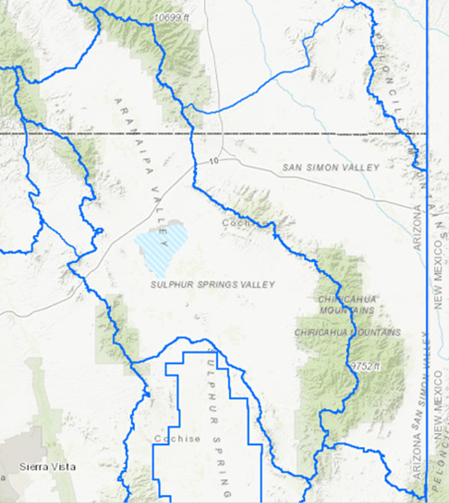
ADWR CELEBRATES NEW, “ALTERNATIVE” ASSURED WATER SUPPLY PATHWAY

PHOENIX – Today Governor Katie Hobbs signed a proclamation celebrating the first implementation of the new “Alternative Designation of Assured Water Supply Program,” commemorating a new pathway for increasing Arizona’s housing supply while at the same time maintaining the vital consumer protections of the State’s landmark Groundwater Management Act.

“This program, dubbed ADAWS, represents the culmination of a challenging public stakeholder process that kept protection of Arizona’s groundwater supplies as a top priority,” said Arizona Department of Water Resources Director Tom Buschatzke.

“I commend Governor Hobbs for her leadership in this effort, and I further commend my hard-working staff for the countless hours they have contributed to making this alternative pathway to an Assured Water Supply a reality for participating providers.”

“The many stakeholders involved in this process have been intensely engaged and determined to find that next adaptation of water policy that allowed incremental, sustainable growth while protecting groundwater. I heartily commend them as well.”

__

See: EPCOR Water Arizona-West Valley System AWS Designation

###

ARIZONA DEPARTMENT OF WATER RESOURCES FIELD HYDROLOGISTS CONDUCTING “BASIN SWEEP” TO COLLECT WATER LEVEL MEASUREMENTS IN TUCSON/SANTA CRUZ AMAS

PHOENIX- Beginning the week of March 3, 2025, and continuing through April 2025, Arizona Department of Water Resources (ADWR) field services staff will make an extensive effort to measure water levels in wells within several groundwater basins in Southern Arizona. This survey of wells – or basin “sweep”, as it is known, was last conducted during the Spring of 2020.

The data collected will be analyzed and used to obtain a comprehensive overview of the groundwater conditions and used to support scientific and water management planning efforts. Among others, data uses will include:

  • Analysis of water-level trends
  • Groundwater modeling
  • Water-level change maps
  • Hydrologic reports
  • Water resource planning and management

The groundwater subbasins that will be targeted are as follows; Avra Valley, Cienega Creek, San Rafael, Santa Cruz AMA and Upper Santa Cruz. These subbasins cover several thousand square miles of Tucson Metro, farmland, riparian areas, Santa Cruz River and rugged terrain in Southern Arizona along the border of Mexico. Additional coverage areas include the cities and towns of Green Valley, Tubac, Nogales, Patagonia and Sonoita.

For more information regarding this matter, please contact Public Information Officer Shauna Evans at smevans@azwater.gov or (602) 771-8079.

Details about the nature of basin sweeps and groundwater modeling can be found here. If you would like to volunteer your well for participation in this groundwater survey please contact the Hydrology Division at (602) 771-8535.

###

Arizona Department of Water Resources field hydrologists conducting “basin sweep” to collect water level measurements in Eastern Arizona

PHOENIX- Beginning the week of December 30, 2024, and continuing through February 2025, Arizona Department of Water Resources (ADWR) field services staff will make an extensive effort to measure water levels in wells within several groundwater basins in Eastern Arizona. This survey of wells – or basin “sweep”, as it is known, was last conducted during the winter 1987.

The data collected will be analyzed and used to obtain a comprehensive overview of the groundwater conditions and used to support scientific and water management planning efforts. Among others, data uses will include:

  • Analysis of water-level trends
  • Groundwater modeling
  • Water-level change maps
  • Hydrologic reports
  • Water resource planning and management

The groundwater subbasins that will be targeted are as follows; Bonita Creek, Duncan Valley, Gila Valley, Morenci and San Carlos Valley. These basins cover several thousand square miles of farmland, riparian areas and rugged terrain in East/Central Arizona along the border of New Mexico, through the Gila Mountains and includes the Town of Safford following the path of the Gila River.

For more information regarding this matter, please contact Communications Administrator Doug MacEachern at dmaceachern@azwater.gov or (602) 771-8507.

Details about the nature of basin sweeps and groundwater modeling can be found here. If you would like to volunteer your well for participation in this groundwater survey please contact the Hydrology Division at (602) 771-8535.

###

Arizona Department of Water Resources field hydrologists conducting “basin sweep” to collect water level measurements in the NW Groundwater Basins: Virgin River, Grand Wash, Shivwits Plateau, Kanab Plateau, Paria, and Coconino Plateau Basins (known mostly as the Arizona Strip region, not including Peach Springs Basin)

PHOENIX – Beginning the week of March 11, 2024, and scheduled to continue for multiple months, Arizona Department of Water Resources (ADWR) field services staff will be making an extensive effort to measure water levels in wells in the NW Groundwater Basins: Virgin River, Grand Wash, Shivwits Plateau, Kanab Plateau, Paria, and Coconino Plateau Basins.  ADWR’s objective is to measure water levels at hundreds of wells in these groundwater basins. This survey of wells – or basin “sweep,” as it is known – was last conducted by the USGS in 1976 for the Grand Wash, Shivwits Plateau, Kanab Plateau, Paria Basins.  ADWR last conducted a sweep in the Virgin River Basin in 1991 and Coconino Plateau Basin in 2004.

The Arizona Strip area has been identified as a critical area that has not had a basin sweep conducted recently (see ADWR publication, Hydrologic Map Series (HMS), Water Level Change Map Series (WLCMS), and Basin Sweep Assessment Report ADWR Basins and Sub-Basins, (2009)

The data collected will be analyzed and used to obtain a comprehensive overview of the groundwater conditions and used to support scientific and water management planning efforts. Data collected will be used for several purposes, including:

  • Analysis of water-level trends
  • Groundwater modeling
  • Water-level change maps
  • Hydrologic reports
  • Water resource planning and management

This basin sweep covers an area generally in the northwestern portion of the state from the Virgin River and Virgin River Mountains, including the Grand Canyon – Parashant NM, north and south rims of the Grand Canyon NP, extending east to Paria Canyon and southeast to the Colorado River west of Page, south to the San Francisco Mountains just northwest of Flagstaff, including Williams..

For more information regarding this matter, please contact Public Information Officer Shauna Evans at smevans@azwater.gov or (602) 771-8079. Details about the nature of basin sweeps and groundwater modeling can be found here.

###