Historically dry winter means Lake Mead may be closer to shortfall than people think

Dry Rockies

LAKE MEAD SHORTFALL AS SOON AS 2019? DON’T WRITE IT OFF

A Q&A WITH THE ADWR DIRECTOR ABOUT POTENTIAL CONSEQUENCES OF AN HISTORICALLY LOW SNOWPACK IN THE ROCKIES

In case you hadn’t noticed, we’ve had some beautiful warm, sunny, dry days of late.

And weeks. And months. The entire Southwest, in fact, has experienced one of the warmest, driest winters on record. For golfing and hiking and living the outdoor lifestyle, that’s great, of course. But, alas, there is an unsettling flip side to all this fair weather.

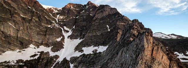
That dark flip side is the possibility of an unprecedented lack of snowpack runoff in the Colorado River system. Forecasts are calling for a continuation of the dry weather into the fast-approaching spring.

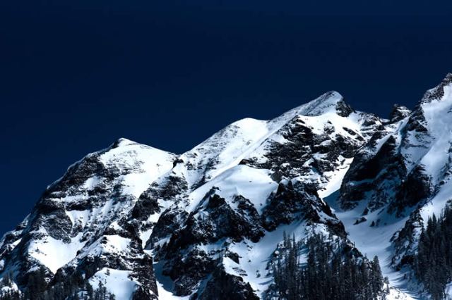
Winter – typically the Southwest’s season for accumulating snowpack in its mountain regions, which provides runoff into reservoirs like Lake Powell and Lake Mead – is nearing its end, regardless what groundhogs in Pennsylvania claim.

Arizona Water News recently sat down with Tom Buschatzke, Director of the Arizona Department of Water Resources, to discuss the consequences of what may be a record-low amount of runoff into the Colorado River system from the 2017-2018 Winter snowpack.

A transcript of that conversation follows:

Arizona Water News: Director Buschatzke, there is a concern that the lack of snowpack in the western Rockies – particularly in the southern sectors of the Rockies – may result in an unregulated runoff into Lake Powell this spring that may be at a record low. How real is that possibility?

Tom Buschatzke: Based on the current snow-water equivalent graphs, regarding that snow-water equivalent in the upper basin of the Colorado River where most of that water is generated is a very real possibility that the snow-water equivalent is tracking lower than 2002, which was the lowest year in recorded history for 100 years of records.

We do know that the runoff is not linear to what the snow-water equivalent is showing, but it is pretty alarming that we are tracking at this point 2002, or actually a little bit below 2002.

AWN: The Bureau of Reclamation has declared that there is almost no chance of a shortfall in water delivered from Lake Mead next year. But is there a chance that those predictions may change as a result of these extremely dry conditions in the Rockies?

TB: Yes, there is certainly a chance that that that prediction, that forecast, may change.

That forecast is based on a release from Lake Powell to Lake Mead of 9 million acre-feet. Normal release is 8.23 million acre-feet. If the unregulated inflow gets to a certain low level, that 9 million acre-feet release won’t occur. You will get 8.23 million acre-feet.

That loss of volume of water (represents) close to 10 feet of elevation in Lake Mead. The Bureau of Reclamation’s current projection — with that 9 million acre-foot release — is about five feet above the shortage trigger, which means that if we get 8.23 (million acre-feet), we could be five feet below the shortage trigger.

If we can’t conserve enough water in Lake Mead to make up the difference, that will be a high bar to achieve between mid-April and the end of July, which would be the time period in which we’d have to do that conservation.

AWN: We’re not the only ones experiencing an abnormally dry winter. California’s snowpack in the Sierra Nevada also is very low right now too. How might that impact California’s stored water in Lake Mead?

TB: If the snowpack in the Sierra Nevada continues to be also very low and the allocations of the State Water Project remain very low, that means southern California is going to get much less water from northern California than it normally does. It also means that they will be looking to make up the difference somehow, and they will be looking probably at the Colorado River to make up that difference.

Potentially, some of that water stored by California – by the Metropolitan Water District (of Southern California), particularly – that is stored in Lake Mead might start coming out of Lake Mead.

There is about 500,000 acre-feet of that water stored. That is over six feet of water under the regulations that control water going in and water going out of Lake Mead. California can take 400,000 acre-feet – or five feet of water (off the top of Lake Mead) – in this calendar year. So, that is a potential that plays into the possibility that the prediction made by Reclamation so far might also change.


AWN: How does the unusually dry winter affect the discussion among the Colorado River states regarding a Drought Contingency Plan? Many Colorado River stakeholders felt that last winter’s higher-than-average snowpack created a so-called “comfort zone” regarding finalizing a DCP. Can they remain comfortable about water in the Colorado now?

TB: So, I think between the states — the state folks who worked on that Drought Contingency Plan – we are in agreement that we need to finalize that Plan.

Some of the individual stakeholders, water-users, etc. that may have believed that there is a “comfort zone,” that we have bought time to further work on the Drought Contingency Plan, I think, need to really address what is happening with the hydrology and the increasing risks of not just the short-term impacts on Lake Mead, but potentially going into a shortage in 2019.

(They need to address the fact that) this bad hydrology also has implications for the future and for the lake falling to those critical elevations that the Drought Contingency Plan was intended to protect.

So, they should not be comfortable about water in the Colorado River. We need to continue to work to finalize the Drought Contingency Plan. And we need to make sure that in Arizona we have the tools in place to make that happen.

AWN: Thank you.

Seriously? Yes, seriously: Drought-busting moisture levels in parts of the state don’t mean the Arizona drought is done

Record snowfall in the Sierra Nevada…double the average snow in parts of the Rockies… one “atmospheric river” after the next hitting the coast…and enough snowpack in the eastern Arizona mountains to give Lake Roosevelt an outside chance of filling up this spring…yet Arizona remains in drought? Yep


The news is abundant in the West about all the moisture abundance occurring nearly – accent, nearly – everywhere.

Western saturation is the biggest story of the winter in the U.S.

In some areas of northern California, rain totals reached 400 percent of normal in December.  January snowpack in the Sierra Nevada mountains stood at 173 percent of normal, the equivalent of 5.7 trillion gallons of water.

It wasn’t just California experiencing all those remarkably wet atmospheric rivers. As early as mid-January, the Colorado River snowpack stood at 57 percent above the long-term median for that time of year and that was before the big storms of early and late February swept through the Rockies.

Westwide SNOTEL Current Snow Water Equivalent (SWE) Percentage of Normal

The U.S. Department of Agriculture’s latest “Westwide SNOTEL Current Snow Water Equivalent Percentage of Normal” maps of the western mountains are more purple than a ripe eggplant, indicating vast swatches of the region with snowpack deeper than 150 percent of average.

All of which sounds splendid, seemingly alive with drought-busting possibilities… until you have a look at the sobering reality on display in the U.S. Drought Monitor short-term report for February in Arizona.

The February Drought Monitor report may provide the best evidence of the 2016-2017 winter in the Western U.S. for three consistent climate truisms:

  • “Weather” is not the same as “climate,” and
  • Drought is more closely aligned with climate than with weather; and,
  • Drought may come and go in a region, but it comes and goes at different paces in different parts of the same region

The February report concluded: “February was a relatively dry month across parts of the state bringing less than 50 percent of normal precipitation over the eastern third of Arizona and a few spots in northwest Arizona.”

U.S. Drought Monitor – Arizona (February 28, 2017)


Relatively… dry?

This may come as a huge surprise to residents of Maricopa, Yavapai, Coconino, Yuma and La Paz counties, where “much wetter than normal conditions” prevailed. But, then, central Arizona is where most of the residents of the state are too. Most Arizonans were getting wet from the same rainstorm.

It’s a big state. As State Climatologist Nancy Selover notes, the big storms brought plenty of cold air and snow to the northern and western parts of the state, but tended to short-shrift the eastern-mountain watersheds: “They have tended to miss the southeast and many of them have missed the White Mountains as well.”

The headwaters of the Salt and Gila rivers are “below average in snowpack for this time of year,” she said. “Though the Verde is above normal.”

That, Selover observed, is “all short-term drought.”

“We have not had the type of precipitation that will replenish our water resources, so we are not anywhere near being over the drought for long-term water resource concerns.”

Still, said Selover, February overall was “a helpful month” in terms of contributing to the 2017 Water Year profile, which depicts healthy moisture levels since October.

The National Weather Service map of Arizona depicting “Seasonal Precipitation, October 2016 – February 2017” may not  have quite the “ripe eggplant” look as the Western snowpack map, but it’s not far off.

A map of the whole Colorado River Basin rainfall for February and the 2017 Water Year through February map

So where does this mostly-better-than-average winter leave Arizona?

As a part of the Southwestern region? Great: “The Upper Colorado Basin is in great shape this year so far, but we need three or four more consecutive years like this to make up for the deficits,” said the State Climatologist.

But Arizona, specifically? Good, sure. But not great:

“For my money, we are entering the 23rd year (of drought) now,” said Selover.

“I think it started in 1994 after the very wet 1993.”


SNOWPACK IN THE ROCKIES: Hey, it’s not ALL about California!

It’s still early, but much of Arizona’s watershed, as well as the western face of the Rockies, is experiencing higher-than-normal precipitation, too


rocky-mountains-in-winter

Nothing against California, you understand. We’re all delighted to hear about this winter’s bounty of rain and snow, especially as it piles high in the Sierra Nevada.

Love all those “atmospheric rivers.”

It is great to hear of expert-level debates over whether the Golden State’s drought designations should be eased — or even lifted entirely — especially in the north of the state.

There are parts of the mountains immediately east of Sacramento and San Francisco that have experienced well over 200 percent of the official average precipitation. As they say in southern Cal: Whoa!

But, well… it’s not all about California, you know.

According to data compiled and analyzed by the National Water and Climate Center, precipitation thus far in the “water year” – that is, the period beginning October 1, 2016 – has been predominately “near to well above average” almost everywhere in the West, except Alaska.

Meanwhile, the snowpack in the southern regions of the Western U.S. – the areas of the West most seriously impacted by record and near-record drought – is being judged “well above average,” according to the results reported in the Water and Climate Center’s Snow Telemetry (SNOTEL) summaries.

That snowpack translates, ultimately, into the statistics that matter most to the 35 million-odd people living in the Colorado River basin: the streamflow forecasts and the expectations for reservoir storage levels. And those are looking better than they have in a long time too:

The SNOTEL measurements depict “well above average streamflow in the middle and southern parts of the West,” and reservoir storage amounts that should be “above average in Montana and Wyoming, near average in Colorado and Nevada.”

As of February 1, the Center is forecasting inflows into Lake Powell at 147 percent of the 30-year average for April through July, a critical streamflow period.

Almost… California-esque.

For Arizona specifically, the precipitation picture has brightened considerably this winter.

“We have to go all the way back to 2010 the last time we filled the reservoirs,” said Salt River Project water operations manager Charlie Ester to 12News on February 2.

“In the seven years since then, we have progressively lowered the reservoirs to the current conditions.”

With much of Arizona’s water supply beginning its annual journey on the western slopes of the Colorado Rockies, the Water and Climate Center’s early February report is promising. January produced 217 percent of normal precipitation in Colorado, and the February 1 snowpack is at 156 percent of normal, up 43 percent from January.

As a result, streamflow forecasts “are nearly all above normal with the western basin projections providing the highest forecasts,” according to the Water and Climate Center report.

Even in the best of times, precipitation never distributes evenly.

As of February 1, the “snow-water equivalent levels” – that is, the amount of liquid, flowing water expected to be produced from a region’s snowpack – range from 88 percent of median in the San Francisco-Upper Gila River Basin to 166 percent of median in the Verde River Basin.

Still: “Cumulative precipitation since October 1 is now well above normal in all major river basins for the water year.”

Precipitation disclaimers in the arid Southwest are always lit bright, however. The remarkable measurements of the winter to date are entirely capable of petering out to nil. Which is a pretty good summary of how last winter went.

A winter’s precipitation is the result of weather. And while drought is a function of weather over time, it isn’t something that disappears in a single, wet season.

The effects of drought, for example, can be cumulative. The volume of Southwestern desert dust that blows east onto the western slopes of the Rockies has been shown to have a cumulative effect on the duration of the winter season.

NOAA’s Cooperative Institute for Research and Environmental Sciences at the University of Colorado Boulder, for example, reported in late 2013 that the snowpack of the Rockies “is melting out as many as six weeks earlier than it did in the 1800s,” as a result of a thick layer of desert dust.

It’s not just drought that impacts Colorado River streamflow, in other words.

Moisture at these levels in the West can make people forget quickly the long-term issues the region faces. Already, Californians are in a fierce debate over whether to extend Gov. Jerry Brown’s emergency drought declaration and whether or not to ease up on other water-conservation efforts.

“Most water agencies have yet to adjust to this ‘new normal’ and are operating on outmoded assumptions and practices that place the state at risk of water shortages and worse,” argued climate-change expert Alex Hall of UCLA in a commentary that appeared February 5 in the Los Angeles Times.

Hall’s concern – that the recent snow and rain will blunt efforts to improve water-use efficiencies in southern California – is a concern for the entire Southwest.

Could this one year’s abundance blunt efforts to resolve the systemic over-allocation of Colorado River water, for example?

If there is a downside to the current – and literal – flood of moisture into the region, it is that.

“While I’m happy about all the snow,” said Water Resources Director Tom Buschatzke, “we don’t have enough certainty about what Mother Nature is going to send us.

“We have to focus on what we have control of.”


Climate vs weather: Is the California drought ending? Not so fast!

desert_electric
Violent electrical storm attacks the California Mojave Desert by Jessie Eastland

In the coming days, the northern Sierra Nevada in California is going to get pounded with a literal rushing “river” of moisture that promises to dump upwards of five feet of snow in some of the mountain range’s higher elevations and as mush as two feet of rain in parts of nothern California.

Within a few days, the mighty system will sweep down into some of the more drought-parched regions of southern California, too.

“This is what we’re supposed to be getting,” Johnnie Powell, a meteorologist at the National Weather Service, told the Los Angeles Times.

“After six years of a drought, I love saying that. This is normal rain and snow that we’re supposed to be getting in December and January.”

So, the end of the five-year California drought is nigh, right? Well, no. It’s not nigh.

The Great California Drought’s end is not nigh for the simple reason that what we are witnessing on the Left Coast is weather. And while an extended “weather” feature like drought is a function of climate, “weather” all by itself is not.

The difference between “weather” and “climate” is a fundamental meteorological distinction.

“Weather is the daily condition of the atmosphere, (including) specifics of temperature, humidity, wind and precipitation,” said Arizona State Climatologist Nancy Selover.

“Climate is the long-term average and extremes of those daily values.”

It is possible, but far from certain, that the enormous “atmospheric river” of precipitation now beginning to batter California is the return to “normal” that Powell of the NWS describes.

That hopeful anticipation is bolstered by other meteorological developments. Northern California also experienced its wettest October in 30 years. And, as reported by the National Weather Service, the same region experienced above-average precipitation in December.

So, is California – and, by extension, the Southwest – out of the drought-woods?

Well, no.

Wet weather is nice, but it would take a long-term trend of similar weather patterns for it to constitute a change in climactic conditions away from the lingering pattern of chronic drought that has left its mark in California for the last five years, as well as in the Southwest for going on 17 years.

And while some parts of the Sierra Nevada range may be getting crazy-deep snow deliveries, the distribution of moisture is far from universal. Despite all that October and December rain and snow, for example, the California-wide snowpack has been measured at just 70 percent of normal, as reported by the California Department of Water Resources.

Of course, that was before that megillah of a storm system began hitting the California northlands – a storm system that, while enormous, still constitutes nothing more than a very encouraging weather pattern.

“We often say, ‘Climate is what we expect, but weather is what we get,’” said Selover.