Arizona Department of Water Resources field hydrologists conducting “basin sweep” to collect water level measurements in the Phoenix AMA

Color Logo Transparent- For Web

PRESS RELEASE

FOR IMMEDIATE RELEASE                                                         December 1, 2022

Arizona Department of Water Resources field hydrologists conducting “basin sweep” to collect water level measurements in the Phoenix AMA

PHOENIX- Beginning the week of December 12, 2022, and continuing through January 2023, Arizona Department of Water Resources (ADWR) field services staff will make an extensive effort to measure water levels in wells in the Phoenix Active Management Area (AMA). This survey of wells – or basin “sweep,” as it is known – was last conducted during the winter of 2016/2017. 

The data collected will be analyzed and used to obtain a comprehensive overview of the groundwater conditions and used to support scientific and water management planning efforts. Among others, data uses will include:

  • Analysis of water-level trends
  • Groundwater modeling
  • Water-level change maps
  • Hydrologic reports
  • Water resource planning and management

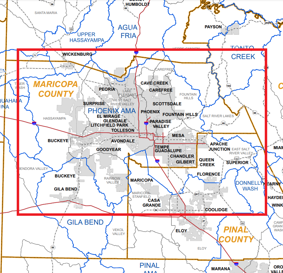
This basin sweep covers an area generally in the central portion of the state and extends west of the Phoenix Metro area past Tonopah, east near the Superstition Mountain and Globe, AZ, north of New River, AZ and south to Sacaton. The Phoenix AMA consists of the following subbasins; Hassayampa, West Salt River Valley, Lake Pleasant, East Salt River Valley, Rainbow Valley, Carefree and Fountain Hills.

Map of the Phoenix AMA

For more information regarding this matter, please contact Public Information Officer Shauna Evans at smevans@azwater.gov or (602) 771-8079. Details about the nature of basin sweeps and groundwater modeling can be found here.

###

Arizona Department of Water Resources field hydrologists conducting “basin sweep” to collect water level measurements in the Western Planning Area: Butler Valley, Harquahala, McMullen Valley, Ranegras Plain, and Tiger Wash Basins

Color Logo Transparent- For Web

PRESS RELEASE

FOR IMMEDIATE RELEASE                                                         January 5, 2022

Arizona Department of Water Resources field hydrologists conducting “basin sweep” to collect water level measurements in the Western Planning Area: Butler Valley, Harquahala, McMullen Valley, Ranegras Plain, and Tiger Wash Basins

PHOENIX – Beginning the week of January 1st, 2022, and scheduled to continue for multiple months, Arizona Department of Water Resources (ADWR) field services staff will be making an extensive effort to measure water levels in wells in the Western Planning Area (WPA): Butler Valley, Harquahala, McMullen Valley, Ranegras Plain, and Tiger Wash Basins.  ADWR’s objective is to measure water levels at hundreds of wells in these groundwater basins. This survey of wells – or basin “sweep,” as it is known – was last conducted in winter 2016 for the WPA.  The Harquahala Irrigation Non-Expansion Area (INA) will also be included in the basin sweep as it is contained within the Harquahala Basin. 

The data collected will be analyzed and used to obtain a comprehensive overview of the groundwater conditions and used to support scientific and water management planning efforts. Data collected will be used for several purposes, including:

  • Analysis of water-level trends
  • Groundwater modeling
  • Water-level change maps
  • Hydrologic reports
  • Water resource planning and management.

This basin sweep covers an area generally in the western to southwestern portion of the State and extends east of Plomosa and Kofa Mountains, west of Big Horn, Vulture and Harquahala Mountains, north of Eagle Tail Mountains and south of Bouse Hills, Buckskin and Harcuvar Mountains. 

For more information regarding this matter, please contact Public Information Officer Shauna Evans at smevans@azwater.gov or (602) 771-8079. Details about the nature of basin sweeps and groundwater modeling can be found here.

###

Arizona Department of Water Resources will survey wells in parts of Yavapai and Coconino Counties

Graphic 2

PRESS RELEASE

FOR IMMEDIATE RELEASE                                  CONTACT: Doug MacEachern      

March 10, 2017                                                             PHONE: 602.771.8507

Arizona Department of Water Resources will survey wells in parts of Yavapai and Coconino Counties  

Phoenix- March 10, 2017 – Beginning in early March, the Arizona Department of Water Resources will be making an extensive effort to measure water levels in wells in the Prescott Active Management Area and the Verde Basin (see attached map).

Every year the Department’s field services technicians collect water levels in a statewide network of about 1,600 to 1,800 “index” wells that have typically been measured annually over the last several decades.  There are roughly 250 groundwater index wells measured annually or semi-annually in the Prescott AMA/Verde Basin region.

During the remainder of the 2017 field season Water Resources staff will measure several hundred wells in the Prescott AMA/Verde River basin area in addition to those 250 index wells.

This 2017 survey of area wells – or basin “sweep,” as it is known — will be the first such basin survey of the area since 2009. The data collected will be analyzed and used to obtain a comprehensive overview of the groundwater conditions and used to support scientific and water management planning efforts.

Frequently Asked Questions about basin surveys:

What will the ADWR do with the data?

The department uses the information from the basin survey to develop water level maps to support scientific, planning and management studies of the basin’s aquifer system.

The department produces invaluable “Hydrologic Map Series” reports, and “Water Level Change” reports which show groundwater conditions statewide.

What if well owners don’t want the ADWR measuring their well depth?

Participation and cooperation with the department’s basin survey is entirely voluntary.

The data collected from basin surveys has proved valuable to property owners and lessees just as much as it is to state and municipal water planners.

Why here? And why now?

Historically, the department measures its index wells in the Prescott/Chino Valley/Verde Basin area in the late winter/early spring. During this time, the water levels in the aquifer have typically recovered from the previous summer “pumping” levels and represent a more “static” condition which gives a more representative picture of what’s happening with the aquifers in the area.

Do well owners and lessees get to review the data?

Arizona Department of Water Resources data are all public records. Data collected should be available by early to mid-summer. As maps are completed, the data will be available via the department’s website at azwater.gov. The department’s Groundwater Site Inventory (GWSI) well database is available at: https://gisweb.azwater.gov/waterresourcedata/GWSI.aspx

For more information regarding this matter, please contact Doug MacEachern, Communications Administrator, at dmaceachern@azwater.gov or (602) 771-8507.

###