Arizona’s Summer Monsoon Season Has Been A Lively One. But ‘Liveliest Ever?’

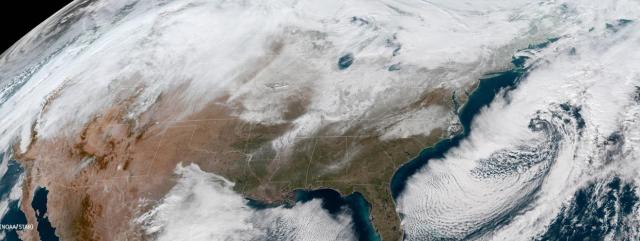
After a so-so start to the southern Arizona summer “monsoon” season, storms pounded Tucson through early August with almost rhythmic frequency.

It was much the same in the metropolitan Phoenix area, which saw an unusual spate of strong storms moving through Arizona’s south-central Valley on five out of six days beginning on August 7.

This year’s summer storm activity has been widespread. Arizona’s eastern mountains saw almost daily rainfall from mid-July through early- to mid-August.  To the north, meanwhile, the strong storms started in earnest early.

Persistent, heavy rain battered the Flagstaff region commencing in mid-July, generating flash floods and localized flooding in many Flagstaff-area neighborhoods.

On July 18, a an estimated “1,000-year” storm dumped an astonishing six inches of rain on Flagstaff, with 4.5 inches of it pouring down in a span of just two hours.

The summer storm season has been so strong at times, in fact, that it has prompted some to ask: Is this the strongest monsoon-storm season ever for Arizona?

There’s no simple answer to that.

Arizona takes its summer monsoon season seriously. There is an extended web of agencies, including the Arizona Department of Water Resources, that performs a vast array of services tied to storm activity.

The National Weather Service, for example, monitors the conditions that may provoke Arizona storms. It reports both locally and from the service’s Climate Prediction Center (a function of the National Oceanic and Atmospheric Administration) in Maryland.

A complex, multi-agency system in Arizona, meanwhile, uses sophisticated land- and satellite-based technology to track storm production, including rain levels and flooding, and gets that information out to the public as soon as possible.

ADWR is the lead State agency for the Arizona Flood Warning System, or AFWS.

The AFWS is comprised of local, state and federal entities that collaborate on statewide strategies for flood management.

Podcast: Arizona Water Resources talks with Brian Cosson, Flood Warning Coordinator for ADWR

So, what is all that data telling us about the strength of the 2018 summer monsoon season thus far? It has set records in Flagstaff. But elsewhere?

Paul Iñiguez, a meteorologist with the NWS in Phoenix, recently told the Arizona Republic that from the standpoint of rainfall, the summer monsoons have been very productive in central Arizona, too.

“From June 15th through August 12th, this is the second most rain on average across (Phoenix) since 1990,” Iñiguez said. “It’s been wet.”

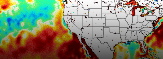
Some of the strength of the summer storms may be derived from “moisture surges” egged along by “tropical cyclones.”

Jon Gottschalck, chief of the Operational Prediction Branch at the Climate Prediction Center with the National Oceanic and Atmospheric Administration, told KJZZ recently about how “tropical cyclones” in the eastern Pacific basin are connected to Arizona’s monsoon storms.

Hurricanes, typhoons and other major Pacific storms all come under the general heading of tropical cyclones.

“Sea-surface temperatures, or ocean temperatures at the surface are strongly positive, meaning warmer than normal,” said Gottschalck. “And when those temperatures that are warmer than normal have been persisting for quite some time, there is more energy for tropical cyclones to develop.”

He said a spate of tropical cyclones in the eastern Pacific likely contributed to the moisture surges in Arizona and New Mexico that, among other things, produced the amazing string of consecutive stormy days in central Arizona.

Big Pacific storms, he said, do not have to  make direct hits on the Southwest to have an impact.

“The systems very often create moisture surges up the coast,” he said. “That very often tends to create stronger coverage of rainfall. In general, these storms don’t have to make direct hits on Arizona and New Mexico to do that.”

(For more on research into monsoon activity in Arizona, view the video below)


Attack of the Blob: How an enormous, persistent arctic low-pressure system is helping dry out the American Southwest

Article_banner_1

It’s… the blob. It came from above. And it’s got the world in its grip.

And… it’s not going anywhere any time soon.

If that sounds like a trailer line for a low-budget sci-fi movie… well, it could be.

But it also fairly describes the powerful “Strong Hudson Bay Low” – an Arctic-spawned low-pressure systemthat locked in place over much of the Northern Hemisphere in mid-November. The strong, static “blocking” system is showing no sign of releasing its grip any time in the foreseeable future.

“WITH SNOW CONDITIONS IN THE UPPER COLORADO RIVER BASIN TRACKING AT JUST 31 PERCENT OF THE TOTAL AVERAGE SEASONAL ACCUMULATION AS OF MID-JANUARY, THE 2018 SEASON IS LOOKING DRYER THAN THE RECORD-DRY 2002 SEASON.”

And neither is one of the stronger regional effects of the huge low-pressure system:

An equally persistent, equally strong high-pressure ridge has locked into place beneath the blob. It sits in an equally unyielding “blocking” pattern over the eastern Pacific and the southwestern U.S., which is driving the west-east jet stream and its storms well to the north of the parched American Southwest.

That strong high-pressure system is proving to be a virtual mirror image of the Strong Hudson Bay Low, driving temperatures dramatically up and sapping the atmosphere of moisture.

“How strong and permanent it becomes depends on establishment of other high- and low-pressure systems as well as the amplitude of the jet stream around the globe,” explained Greg Smith, a senior hydrologist at the Colorado Basin River Forecast Center, a division of the National Weather Service and the National Oceanic and Atmospheric Administration.

Coming at the time of year when the western slopes of the Rocky Mountains typically build snowpack that, come spring, provides run-off into the Colorado River system, the moisture-robbing effects of this static high-pressure system may prove to be record-setting.

So too might the effects of the Artic blob.

On January 2 in the U.S., at least one location in all 50 states recorded temperatures below freezing. Yes, even in Hawaii.

Water fountains in Florida froze over. Off-shore, sharks swimming near Cape Cod froze to death. And all that occurred before the infamous “bomb cyclone” drove temperatures deeply negative on the entire East Coast for nearly a week.

On the opposite side of the globe, meanwhile, it’s the same deal. The Arctic blob has much of the eastern side of the Northern Hemisphere frozen and snow-bound, too.

In Yakutia, Siberia – 3,300 miles east of Moscow – residents reported their eyelashes freezing as temperatures dropped to an astonishing 88 degrees below zero Fahrenheit. In southwestern Scotland — typically cold and wet in the winter — blizzard conditions shut down highways. And shipping on the normally blue Danube – for now, icy gray – was halted because of ice.

All weather patterns being inter-related with all other weather patterns, the powerful high-pressure ridge sitting over much of the southwestern U.S. built up around the same time as the Strong Hudson Bay Low gathered its global steam – in mid-November.

And like its Hudson Bay “polar” opposite, there it has remained. And remained. Strong. Resolute. And dry.

While neither strong low-pressure systems that sweep down from the Arctic nor high-pressure ridges laying out over the western U.S. are unusual at this time of year, these systems are unique in one important respect: their persistence. They won’t quit.

The high-pressure ridge has proved so persistent – and the conditions it creates so dry – that hydrologists at the Forecast Center now are comparing this season’s snowpack in the Rockies (as well as in the Arizona mountains) to that of the infamously dry winter of 1976-1977, which produced one of the lowest inflows into Lake Powell on the Colorado River system on record.

How low did that inflow go?

The fall-winter “water year” season that ended in 1977 produced an unregulated Colorado River inflow into Lake Powell of roughly 5.8 million acre-feet. That is almost three million acre-feet less than the average river flow into Powell since 2000, a period when much of the Southwest, including Arizona, has been locked in chronic drought.

Measured against the historic average since 1964, the 1977 inflow into Powell was almost five million acre-feet below average. Since 1964, only three seasons have provided less runoff than 1977.

“What drew us to the comparison (with 1977) initially was the snow situation,” said Smith.

The Forecast Center’s highly advanced “SNOTEL” (for “snow telemetry”) network indicated that many of the Colorado River Basin’s snowpack areas, especially in the southern regions, were experiencing the “lowest snow on record,” according to Smith.

To Smith and other hydrologists, the atmospheric patterns prompting the weak snowpack seemed familiar:

“Some of us recall how poor conditions were in 1976-77. Then we noticed these large atmospheric features — strong low in the east and ridge in the west — were similar.”

Added Smith: “These are not uncommon features from year to year. But in both 1976-1977 and this year they were fairly strong, and the jet stream flow in the atmosphere similarly had a high amplitude. These strong low- and high-pressure systems, known as blocking features, or a blocking pattern, can be quite stubborn.”

As it stood in mid-January, the estimate for unregulated inflow into Lake Powell from the western slopes of the Rockies indicated the lake would receive 6.75 million acre-feet of runoff, or 62 percent of the historic, 30-year average. Not good, obviously. But not historically bad.

That estimate may be changing, however. And not for the better.

The lowest Colorado River inflow into Powell ever recorded was about 2.3 million acre-feet in 2002.

With snow conditions in the Upper Colorado River basin tracking at just 31 percent of the total average seasonal accumulation as of mid-January, the 2018 Water Year season – at this point in time — is looking dryer than the record-dry 2002 season.

A “snapshot” chart recently released by the federal Bureau of Reclamation compares the current water-year snow conditions with Water Year 2002. As of January 17, which is 57 percent through the snow-accumulation season, snow conditions were tracking well below conditions in 2001-2002.

Caveats apply, certainly.

Weather changes. The “blocking” low- and high-pressure systems could weaken and dissipate. And we are still relatively early in the snow-accumulation season. The very dry mid-January snapshot of conditions could look very different by mid-February.

As Smith notes, the 1976-1977 pattern finally broke down in March 1977, ushering in a much wetter late-winter period, especially in the northern Colorado and Great Basins.

As our days of unnervingly pleasant sunshine and annoyingly dry, easy breezes drone on – and on – the prospects for matching (or, gulp, “besting”) the Great Colorado River Dribble of 2002 increase.

But, again, as the forecasters well know, weather changes. Even the extraordinarily dry winter of 1977 ended pretty wet.


Panel recommends Arizona drought declaration continue for umpteenth year

Banner from Slide

It is, indisputably, the best weather show in Arizona all year.

Nothing against the fine work of Arizona’s TV weather forecasters and meteorologists, but the best two hours of weather analysis, climate analysis, near-term predictions, long-term predictions, precipitation, Colorado River flows and the various impacts of all of it is the report of the Governor’s Drought Interagency Coordinating Group.

On Tuesday, the panel of water-weather-climate-watershed experts concluded Arizona remains in a state of drought.

As they have consistently since 1999, the coordinating group’s members voted to make an official recommendation that a letter be sent to the Arizona Governor alerting him to that fact.

The recommendation will serve as the basis for an official drought declaration from Gov. Doug Ducey.

“Our outlook has improved and there have been a lot of proactive efforts to mitigate our (water) risks,” said Wendy Smith-Reeve of the Arizona Division of Emergency Management. Together with Arizona Department of Water Resources Director Tom Buschatzke, Smith-Reeve co-chairs the coordinating group.

“(But) while our short-term outlook is positive, long-term recommends we continue with a drought declaration,” she said. “This is not the time to stop pressing forward.”

Preceding that decision was some of the clearest and most precise weather-climate analysis provided anywhere in the state.

State Climatologist Nancy Selover and Mark O’Malley of the National Weather Service provided a near-term retrospective and near-term prediction, respectively, on the state’s weather.

Arizona State Climatologist Nancy Selover

A thumbnail: weather in the recent past has been a little wetter; weather in the near future, meanwhile, looks at least 50-50 to stay that way.

“Our monsoon picked up a lot of good activity, but for the short-term it still has been a little dry in the southern part of the state,” said Selover, analyzing the 2016 summer storm season.

Regarding the approaching summer monsoon season, O’Malley explained that the intensity of the rainy season will be determined by the “persistence” of a subtropical high-pressure system.

“If the high (pressure system) moves to the north (of Arizona), we get the moisture,” he said.

O’Malley said there is a “50-50” chance that conditions this summer will be ripe for the advent of a so-called “El Nino” weather pattern, which enhances the prospects of moisture in Arizona.

“Same for the (2017-18) winter,” he added.

As for air temperatures this coming summer, stow the sweaters: “It’s very favorable that we’ll be warmer than average,” he said.

Conditions at Lake Mead and on the Colorado River, meanwhile, are moderately improved from last year, continuing the trend of positive effects arising from the strong, early-winter snowstorms in the western Rocky Mountains, said Jeff Inwood of the Department of Water Resources.

Mark O’Malley of the National Weather Service

A warmer, “less wet” spring, however, kept the snowpack from fueling a banner-year runoff into the Colorado River system, said Inwood. Nevertheless, the good (if not quite ‘great’) news is that Lake Mead water levels stand now at about ten feet higher than at this time last year.

Inwood’s report, of course, directly impacts the on-going drama surrounding the chances that Lake Mead may descend to a depth that would trigger a water-delivery shortage declaration for Colorado River water users.

“As a result of the improved hydrologies, we are seeing decreased probabilities of a shortage,” said Inwood.

The report on Colorado River conditions dovetailed with the next presentation, a report on progress toward a drought contingency plan – including both inter- and intra-state agreements – by Water Resources Director Buschatzke.

Buschatzke, too, observed that “we’re in good shape going forward,” but reminded the audience that the chronic structural imbalance in Lake Mead remains. About 1.2 million acre-feet more water is extracted from the reservoir each year than on average flows into it.

Arizona Department of Water Resources Director Tom Buschatzke

Buschatzke updated the coordinating group on the progress of drought contingency planning negotiations.

The Water Resources director also reported that the Fiscal Year 2018 state budget recently passed by the Arizona Legislature included $2 million for each of the next three years for funding conservation efforts in Lake Mead.

Charlie Ester of Salt River Project reported that Arizona’s mountains enjoyed a wetter-than-average winter season, too. But not a record-breaker.

By mid-winter, SRP was crossing its fingers for a snowpack that might fill its premier reservoir, Roosevelt Lake. A dry April and snowfall that “didn’t slide” into the White Mountains — the main watershed for Roosevelt Lake – kept the big reservoir at just 76 percent of capacity, he said.

Still, inflow into Roosevelt wasn’t shabby: Prior to the winter snows, Roosevelt had dropped to just 44 percent of capacity. 

Charlie Ester, Salt River Project

The snowpack in Arizona’s Ponderosa pine country, meanwhile, was good enough to make the state’s approaching fire season “manageable,” said Jeff Whitney of the Arizona Department of Forestry and Fire Management.

In the forests, said Whitney, “we’re looking at a ‘normal’ year.”

“It’s not out of the realm of probability that we could have an upper-elevation fire,” he said. “But I see it being manageable.”

The real challenge, he said, would be in lower-elevation grasslands, which feasted on winter rains and now present a serious fire danger. Whitney noted the southern Arizona Sawmill Fire, which consumed 47,000 acres of mostly grasslands, as well as the smaller Mulberry Fire.

Thanks to the prospects of an earlier-than-average monsoon season, he said, “we are guardedly optimistic – with the caveat that we will have an elevated amount of lightning.”

At that, the co-chairs recommended – and the coordinating group unanimously supported – a recommendation of another drought declaration to be sent to the governor.