Facing Down Arizona’s Impending Wildfire Season

Article_banner-Wildfire
Flames and smoke rise from last year’s fire near Mayer, Ariz. (Jennifer Johnson/AP)

6 questions for Tiffany Davila of the Arizona Department of Forestry and Fire Management

Tiffanie_NEW
Tiffany Davila, public information officer for Forestry and Fire Management

Among its many duties focused on the protection and health of Arizona’s forestlands, the Forestry Department provides public outreach through various platforms including social media, billboard marketing campaigns, public service announcements, and community-wide events – all of it focused on informing Arizonans about the condition of their forests and the need to protect this valuable resource.As Arizona warily approaches an early summer fire season marked by record-low watershed runoff and tinder-dry forests, the Arizona Department of Forestry and Fire Management is gearing up for what many fear may be a challenging time ahead.

Much of that work falls to Tiffany Davila, a public information officer for Forestry and Fire Management. Tiffany has long been a familiar face among Arizona media covering wildfires in Arizona, providing up-to-date information on many of the more serious conflagrations that plague the state at this time of year.

Arizona Water News recently caught up with Tiffany to get her sense of what lies ahead for Arizona’s forests.

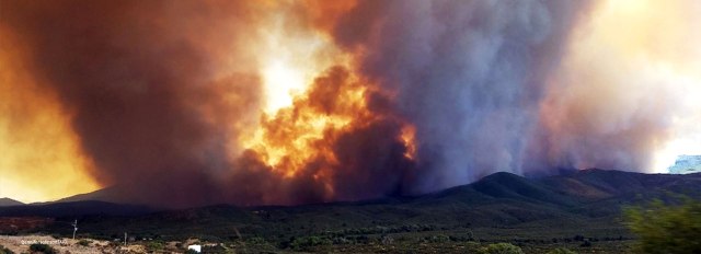
Arizona Water News: With the human-caused Rattlesnake Fire southwest of Alpine, the state’s wildfire ‘season’ already seems to be underway. Are we seeing an unusually early start this year for forest fires?

Tiffany Davila: Unfortunately, there doesn’t seem to be a ‘season’ anymore. Wildfire activity picks up every month nowadays. This January and February we had fire activity across southern Arizona and we expect it to get even busier across the entire State as we move into the warmer months.

The Rattlesnake Fire, posted to Inciweb approximately April 20, 2018. Photographer unknown;

Last year, the Sawmill Fire started on April 23rd and burned nearly 47,000 acres. This year, the Rattlesnake Fire started even earlier and has already reached 22,000 acres.

Southern Arizona was very active last year. But this year is different. The lack of precipitation over the winter and increasingly warm temperatures means a decrease in fuel moisture. Therefore, the fire outlook predicted is for high wildfire activity across all of Arizona.

AWN: Rangers in the Tonto National Forest reported issuing 300 warnings and citations between April 20 and 22 for violations of Stage II fire restrictions in the forest – violations that include use of wood and charcoal in campfires, smoking outdoors, parking on dry vegetation. Is it tough getting out the message that these are extremely dangerous things to do in the forest at this time of year?

TD: It’s very hard and at times I feel like a broken record repeating the same things: ‘Don’t drag tow chains… put out your campfires completely… create defensible space… don’t burn on windy days…’ I think I even say it in my sleep.

But seriously, if we keep reinforcing and pushing the messaging it will eventually stick with folks. Many times, people become complacent and yes, accidents do happen, but one spark is really all it takes to start a major wildfire and that’s why it’s very important we continue our marketing efforts to push out our prevention messaging year-round.

AWN: On the plus side, cooler weather and lighter winds for several days have appeared to have helped firefighters with the Rattlesnake Fire. On the minus side, forecasters anticipate dry lightning moving into Arizona during the coming weekend. Is it fair to say you have a love-hate relationship with the weather service at this time of the year?

TD: Actually, we have a love-hate relationship with mother nature. Ha! The forecasters are just doing their jobs. We are fortunate that all our forecasters excel at what they do.

The weather service is very good at keeping us briefed on incoming or poor weather conditions during a fire. In a critical fire situation, we can call them for a spot weather report and they will immediately get us the data we need. Spot weather forecasts are very important because they are based off a pinpointed location of a fire and can be customized to that area.

The forecasters help us do our jobs more effectively and safely and we thank them for that.

AWN: Governor Ducey recently announced doubling his request for fire prevention funding this year to $2 million. How does that funding get used?

TD: That funding is specific for the Department of Forestry and Fire Management’s Hazardous Vegetation Removal program. We use that funding to conduct mitigation projects across the state.

We have several ongoing projects, including one in Safford that is targeting the salt cedar along the Gila River Corridor. Salt cedar, or tamarisk, is a highly flammable and invasive plant that can cause a fire to spread fast and burn very hot. Since last fall, DFFM crews have been working to remove the salt cedar and treat it with herbicide to prevent it from growing back.

Another project that was part of our HVR funding was the fuel break project near Mayer. The 270-acre fuel break installation was a multi-year project that essentially created a buffer zone for the town of Mayer. The break was tested after last year’s Goodwin Fire and proved successful in stopping the fire from moving into the town.

HVR funding is essential for our work, and having that additional money, should the Legislature approve, will be critical in allowing us to do more projects in high-risk areas around our state.

AWN: The communications team at Forestry and Fire Management notoriously gets zero rest when a major fire breaks out. Can you tell us what you do to keep Arizonans aware of things during a fire incident?

TD: We just drink a lot of coffee and energy drinks. I think last year, I worked more than 100 hours during the first seven days the Sawmill Fire started. I’m not even sure how that’s possible.

We have multiple ways to get information out to the public, and one of them is using InciWeb, a public website. There, the public can find evacuation or road closure notices, fire size and containment numbers, pictures, maps, and other information they may be looking for or needing.

We also work closely with our county emergency managers, the sheriff departments, the Arizona Department of Transportation, the Red Cross and, of course, our partnering agencies — the Bureau of Land Management and the Forest Service — to make sure we are getting the public the pertinent information they need in a timely manner.

Often, we conduct public meetings or town halls to ensure we are reaching all the residents impacted by a fire. We also use ‘trap lines,’ which are basically informational booths, that we set up throughout impacted communities, like at a convenience store or post office, where residents can get information on fire size, suppression efforts, and assistance services, like the Red Cross.

And we can’t forget about social media! The Arizona Department of Forestry and Fire Management uses social media to update the public once a fire breaks out and throughout its duration.

Every fire is different, so each requires a different approach from a public information standpoint. In the end, our goal is to make sure our residents are safe, and they are getting the information they need to keep them briefed and try to make them at ease during tense situations.

AWN:  Your Twitter handle is “asusundevils2000.” Just how big a Sun Devils fan are you?

TD: Let’s just say I bleed maroon and gold. I’m a huge Sun Devil fan! How can I not be? I’m a native Arizonan! I graduated from Arizona State University’s Walter Cronkite School of Journalism and Mass Communication and I am a football season ticket holder! My grandparents were season ticket holders for decades and used to take my brother and I to football games and it just became a family tradition. Our whole family supports ASU, not only the football program, but the institution itself! Forks up! Go Devils!


Panel recommends Arizona drought declaration continue for umpteenth year

Banner from Slide

It is, indisputably, the best weather show in Arizona all year.

Nothing against the fine work of Arizona’s TV weather forecasters and meteorologists, but the best two hours of weather analysis, climate analysis, near-term predictions, long-term predictions, precipitation, Colorado River flows and the various impacts of all of it is the report of the Governor’s Drought Interagency Coordinating Group.

On Tuesday, the panel of water-weather-climate-watershed experts concluded Arizona remains in a state of drought.

As they have consistently since 1999, the coordinating group’s members voted to make an official recommendation that a letter be sent to the Arizona Governor alerting him to that fact.

The recommendation will serve as the basis for an official drought declaration from Gov. Doug Ducey.

“Our outlook has improved and there have been a lot of proactive efforts to mitigate our (water) risks,” said Wendy Smith-Reeve of the Arizona Division of Emergency Management. Together with Arizona Department of Water Resources Director Tom Buschatzke, Smith-Reeve co-chairs the coordinating group.

“(But) while our short-term outlook is positive, long-term recommends we continue with a drought declaration,” she said. “This is not the time to stop pressing forward.”

Preceding that decision was some of the clearest and most precise weather-climate analysis provided anywhere in the state.

State Climatologist Nancy Selover and Mark O’Malley of the National Weather Service provided a near-term retrospective and near-term prediction, respectively, on the state’s weather.

Arizona State Climatologist Nancy Selover

A thumbnail: weather in the recent past has been a little wetter; weather in the near future, meanwhile, looks at least 50-50 to stay that way.

“Our monsoon picked up a lot of good activity, but for the short-term it still has been a little dry in the southern part of the state,” said Selover, analyzing the 2016 summer storm season.

Regarding the approaching summer monsoon season, O’Malley explained that the intensity of the rainy season will be determined by the “persistence” of a subtropical high-pressure system.

“If the high (pressure system) moves to the north (of Arizona), we get the moisture,” he said.

O’Malley said there is a “50-50” chance that conditions this summer will be ripe for the advent of a so-called “El Nino” weather pattern, which enhances the prospects of moisture in Arizona.

“Same for the (2017-18) winter,” he added.

As for air temperatures this coming summer, stow the sweaters: “It’s very favorable that we’ll be warmer than average,” he said.

Conditions at Lake Mead and on the Colorado River, meanwhile, are moderately improved from last year, continuing the trend of positive effects arising from the strong, early-winter snowstorms in the western Rocky Mountains, said Jeff Inwood of the Department of Water Resources.

Mark O’Malley of the National Weather Service

A warmer, “less wet” spring, however, kept the snowpack from fueling a banner-year runoff into the Colorado River system, said Inwood. Nevertheless, the good (if not quite ‘great’) news is that Lake Mead water levels stand now at about ten feet higher than at this time last year.

Inwood’s report, of course, directly impacts the on-going drama surrounding the chances that Lake Mead may descend to a depth that would trigger a water-delivery shortage declaration for Colorado River water users.

“As a result of the improved hydrologies, we are seeing decreased probabilities of a shortage,” said Inwood.

The report on Colorado River conditions dovetailed with the next presentation, a report on progress toward a drought contingency plan – including both inter- and intra-state agreements – by Water Resources Director Buschatzke.

Buschatzke, too, observed that “we’re in good shape going forward,” but reminded the audience that the chronic structural imbalance in Lake Mead remains. About 1.2 million acre-feet more water is extracted from the reservoir each year than on average flows into it.

Arizona Department of Water Resources Director Tom Buschatzke

Buschatzke updated the coordinating group on the progress of drought contingency planning negotiations.

The Water Resources director also reported that the Fiscal Year 2018 state budget recently passed by the Arizona Legislature included $2 million for each of the next three years for funding conservation efforts in Lake Mead.

Charlie Ester of Salt River Project reported that Arizona’s mountains enjoyed a wetter-than-average winter season, too. But not a record-breaker.

By mid-winter, SRP was crossing its fingers for a snowpack that might fill its premier reservoir, Roosevelt Lake. A dry April and snowfall that “didn’t slide” into the White Mountains — the main watershed for Roosevelt Lake – kept the big reservoir at just 76 percent of capacity, he said.

Still, inflow into Roosevelt wasn’t shabby: Prior to the winter snows, Roosevelt had dropped to just 44 percent of capacity. 

Charlie Ester, Salt River Project

The snowpack in Arizona’s Ponderosa pine country, meanwhile, was good enough to make the state’s approaching fire season “manageable,” said Jeff Whitney of the Arizona Department of Forestry and Fire Management.

In the forests, said Whitney, “we’re looking at a ‘normal’ year.”

“It’s not out of the realm of probability that we could have an upper-elevation fire,” he said. “But I see it being manageable.”

The real challenge, he said, would be in lower-elevation grasslands, which feasted on winter rains and now present a serious fire danger. Whitney noted the southern Arizona Sawmill Fire, which consumed 47,000 acres of mostly grasslands, as well as the smaller Mulberry Fire.

Thanks to the prospects of an earlier-than-average monsoon season, he said, “we are guardedly optimistic – with the caveat that we will have an elevated amount of lightning.”

At that, the co-chairs recommended – and the coordinating group unanimously supported – a recommendation of another drought declaration to be sent to the governor.

Drought to continue in Arizona? We’ll find out tomorrow

May 2 2017 drought monitor report

The water-news cycle has drifted east all the way across the continent.

It seems like just yesterday the drought story was all about California. Now, the nation’s eyes have shifted all the way from the Left Coast to the Right Coast as drought worries have ebbed in the Land of Avocadoes, but have intensified in the Land of Grapefruit.

Not to be snowflake-y about it, but what about us and our needs? Arizona has been dealing with this drought phenomenon far longer than California and Florida combined.

The formal process to determine whether Arizona officially will enter its 18th consecutive year of drought is approaching.

The Governor’s Drought Interagency Coordinating Group will meet tomorrow, May 9, here at the Arizona Department of Water Resources (1110 W. Washington St., Phoenix, Suite 310, 10 a.m. – 12 noon). And while the details about Arizona’s climactic conditions no doubt will prove fascinating, the ultimate conclusions of the panel don’t look all that much in doubt.

Although dry conditions have ebbed, particularly through the most recent winter months, Arizona continues to see a substantial portion of its territory in drought. The drought portrait has improved considerably since early 2016 — only a tiny portion of southwestern Arizona remains in a “severe drought” condition, which is the second-highest drought category.

The coordinating group will report on drought conditions, Colorado River water-supply conditions and the weather outlook for the upcoming summer and winter seasons.

Parking is limited, so it helps to RSVP by email to ehenenson@azwater.gov. The meeting also will be available via phone and webinar.

To attend the meeting via phone and webinar: Call-in Number: 1-877-820-7831 / Passcode: 886948#

Web Meeting Link: https://stateofarizona.centurylinkccc.com/CenturylinkWeb/Verdes

At the end, the ICG will be asked to make a recommendation to Gov. Doug Ducey about whether or not he should keep the drought declarations currently in place.

Soggy Tucson: UA researchers find Old Pueblo gets more monsoon action than anywhere else

california-rainstorm

What happens in Tucson appears to stay in Tucson — at least when the things “happening” in the Old Pueblo are the effects of strong summer thunderstorms.

Tucson and southern Arizona get more Wagnerian excitement –– and suffer more economic harm — from severe “monsoon” storms than any other Southwestern metropolis, according to a pair of researchers from the University of Arizona.

At over 6.08 inches of rain falling during the hot, muggy monsoon season, Tucson leads the Southwestern pack. It gets nearly an inch more than the next soggiest community, El Paso, and easily twice as much as that place north of the Gila River, metro Phoenix.

Like Phoenix, Tucson is an extraordinarily stable environment. It is not in an earthquake zone. Hurricanes rarely make it to southern Arizona intact. And damaging winter weather is a non-starter. There’s a good reason why the local chambers of commerce tout the climate.

Indeed, the report’s authors go out of their way to note that “Tucson’s weather also provides opportunities for economic activity, including a vibrant winter tourism economy and growing solar industry across Southern Arizona.”

And, really, in an environment that in recent years has endured chronic drought, the main effect of summer monsoons is a big attraction. We like water falling in great gobs from the sky.

But something has to top every community’s list of “most damaging” weather effects, even if those effects themselves are comparatively modest.

In Tucson, it’s those often-sensational monsoons, which according to UA researchers Laura A. Bakkensen and Riana D. Johnson account for 84 percent of all “extreme” weather events there and 96 percent of all property losses.

Notably, the Bakkensen/Johnson white paper did not include the net impact of long-term drought.

On the other hand, it did illustrate the most effective ways to mitigate the impacts of those unpredictable monsoons, most of which Southwesterners already “get.”

Like not driving on Interstate 10 between Tucson and Phoenix when it gets dark and windy. Like not pushing the limits of “stupid driver” laws by driving into running washes after summer storms. And, not least, buying a little home and car insurance.

NPR’s interview with Colorado River author misses an important angle: The effort to save Lake Mead

Where the Water Goes by David Owen

National Public Radio has some of the best interviewing talent in American journalism, and there’s none better than Terry Gross, whose Peabody Award-winning weekday program, “Fresh Air,” has consistently delivered provocative and fascinating interview sessions. On radio, there’s really none better.

But, let’s face it Westerners, the perspective of much of NPR’s programming is often East Coast-centric. Gross’s interview on Thursday with the author of a new book on the Colorado River is further evidence that if they don’t know about it in New York… well, it just isn’t.

Where the Water Goes: Life and Death Along the Colorado River (Penguin Group USA) by David Owen by and large is an honest and fair assessment of the challenges facing the Colorado River today — a source of water for over 35 million people living in the American Southwest. Especially in the face of long-term, chronic drought, those challenges have been daunting. Owen chronicles most of them in Where the Water Goes, including the tender status of Lake Mead, the largest reservoir on the Colorado River system, which today is less than 40 percent full.

In his NPR interview with Gross, Owen explained the 1922 agreement among the federal government and the Colorado River states to apportion shares of the river’s water. The long-standing agreement, as it has turned out, is one of the biggest reasons why Lake Mead is in danger of descending now to “deadpool” level, the critical point at which water may no longer flow out of the lake. Said Owen:

“It’s one of these great sort of ironies of history that in the 19 – the 1920s were some of the wettest years in that part of the country since the 1400s. So the river at that time was carrying more water than ever. And so when the states divided up the river, they were dividing up – actually water that didn’t exist. On the other side, the good side is that, well, it’s almost a century later and that compact, the agreement among those states, still exists.”

Owen’s assessment is pretty much spot on… as far as it goes. But what he leaves out in his interview with Gross is some vital perspective: Fixing that structural deficit created in 1922 is the consuming issue facing Colorado River water managers today.

It’s not like they’re all slapping their foreheads, going, “Oh, that’s why we’re in this mess!”

Addressing the structural deficit is one of the highest priorities of the “Drought Contingency Plan,” or DCP, that the river states and the federal government have been negotiating for nearly three years. See: here, here, here, here, here, here, here, here, here and…(whew!) here.

We appreciate Owen and Terry Gross educating NPR’s mostly waterlogged, mostly Eastern audience about the challenges facing the much more arid West. Just because California and much of the West has gotten drenched of late doesn’t mean pursuing a DCP is any less of a priority.

There really is another important chapter to that story about where the water goes. It’s about the effort to keep a lot of it in Lake Mead.


Weather and climate in the Southwest: Part Two

This is the second part of a discussion with Arizona’s top weather climatologists about drought, rainy winters and why California gets so much more of those “atmospheric rivers” than we do

storm over monument valley

In this discussion with Arizona’s top weather climatologists about the long (and continuing) drought in the Southwest, we talk about the reasons behind the abundant moisture during the 2016-2017 winter and expectations for the future (cross your fingers!).

Today’s talk features Mark O’Malley, forecaster and Climate Science Program manager for the National Weather Service.

Published on March 8, Part One featured an interview with Arizona State Climatologist Nancy Selover. Dr. Selover is the Julie Ann Wrigley Global Institute of Sustainability Research Professor at Arizona State University’s School of Geographical Sciences and Urban Planning in the College of Liberal Arts & Sciences.

Selover and O’Malley are the co-chairs of the State Drought Monitoring Technical Committee, which is responsible for gathering and analyzing data regarding Arizona drought, climate and weather.

The information they provide is used by the Governor’s Interagency Coordination Group, which makes an annual recommendation to the Arizona Governor about whether the state’s long-running state of drought should be extended. Or… not. Arizona Department of Water Resources Director Tom Buschatzke co-chairs the ICG.

Climate science – a field of study that has evolved rapidly in this century – examines a phenomenon like “drought” from an increasing number of factors.

For one thing, it makes the recommendation to the governor on whether to continue the drought declaration more precise.

Drought impacts can range from a lack of soil moisture, affecting range land and farming, to water levels in the state’s reservoirs. And all of the factors that climatologists weigh when deciding whether drought exists can vary widely in time and scale. But all the drought factors taken together make it more difficult to establish with certainty when a drought may begin or end.

“I think it’s generally accepted that Arizona is in a standing, long-term drought since 1999,” said Mark O’Malley of the National Weather Service.

“But clearly there are years and parts of years in the past 17 years where drought has been less expansive and less intense. There really is no good way to say drought in Arizona started on ‘x’ day in 1999.”

Like State Climatologist Nancy Selover – O’Malley’s co-chair on the State Drought Monitoring Technical Committee – O’Malley sees the effects of the very wet 2016-2017 winter as a real positive for most of Arizona. But the slowly improving drought conditions locally are impacted by the summer monsoons, too, he notes.

“We have experienced three to four excellent summer monsoon seasons where thunderstorms and rainfall across the state have been quite good, but we’ve also had five consecutive winters with below average snow in the mountains,” said O’Malley. And it is that snowpack in the mountains that is important for the state’s water supply.

“This winter has been good — especially around the Flagstaff area — but doesn’t totally compensate for the five previous dry winters.”

In terms of moisture, “good” in Arizona consistently is less good than on the California coast, where unprecedented winter moisture largely has ended that state’s drought. There are a number of reasons for that phenomenon, says O’Malley. Some are atmospheric. Some are geographic.

For one, he notes, central and northern California are at higher latitudes than Arizona, and so more commonly fall under the jet stream – which also explains why even during the sodden 2016-2017 winter, Los Angeles and San Diego are getting less moisture than, say, Sacramento.

Then there is the effect of those mountains separating the coastal cities from Phoenix, which, among other things, tends to wring out moisture from those Pacific storms as they sweep inland.

“Moisture from the Pacific streams unencumbered into the coastal cities with lift provided by air flowing over the mountains providing even more rain and snow,” said O’Malley.

“As the air flows over the mountains into far southeastern California and Arizona, it sinks. And you generally need air rising to produce precipitation.”

Often, he notes, there is “nothing left over for Arizona” in those storms. “This is why the deserts from Yuma through Death Valley, Calif., are the driest places in the United States.”

With California reservoirs literally overflowing and with Los Angeles Mayor Eric Garcetti calling for a state of emergency as a result of the melting snowpack in the eastern Sierra Nevada, California is confident – for now, at least – that it is nearly free of drought.

What about Arizona?

“By both objective measures and impacts, drought in Arizona is certainly better  — which is to say, we have less drought — than last year at this time, and substantially better than two to three years ago,” said O’Malley.

“I wouldn’t go as far as using the term ‘waning’ — that word infers a resolution or termination in the immediate future.”

It doesn’t take much for an arid state to slip back into serious, widespread drought conditions.

“Bottom line, because of our location, growing population, and demand for water, Arizona will always be susceptible to drought.”


Seriously? Yes, seriously: Drought-busting moisture levels in parts of the state don’t mean the Arizona drought is done

Record snowfall in the Sierra Nevada…double the average snow in parts of the Rockies… one “atmospheric river” after the next hitting the coast…and enough snowpack in the eastern Arizona mountains to give Lake Roosevelt an outside chance of filling up this spring…yet Arizona remains in drought? Yep


The news is abundant in the West about all the moisture abundance occurring nearly – accent, nearly – everywhere.

Western saturation is the biggest story of the winter in the U.S.

In some areas of northern California, rain totals reached 400 percent of normal in December.  January snowpack in the Sierra Nevada mountains stood at 173 percent of normal, the equivalent of 5.7 trillion gallons of water.

It wasn’t just California experiencing all those remarkably wet atmospheric rivers. As early as mid-January, the Colorado River snowpack stood at 57 percent above the long-term median for that time of year and that was before the big storms of early and late February swept through the Rockies.

Westwide SNOTEL Current Snow Water Equivalent (SWE) Percentage of Normal

The U.S. Department of Agriculture’s latest “Westwide SNOTEL Current Snow Water Equivalent Percentage of Normal” maps of the western mountains are more purple than a ripe eggplant, indicating vast swatches of the region with snowpack deeper than 150 percent of average.

All of which sounds splendid, seemingly alive with drought-busting possibilities… until you have a look at the sobering reality on display in the U.S. Drought Monitor short-term report for February in Arizona.

The February Drought Monitor report may provide the best evidence of the 2016-2017 winter in the Western U.S. for three consistent climate truisms:

  • “Weather” is not the same as “climate,” and
  • Drought is more closely aligned with climate than with weather; and,
  • Drought may come and go in a region, but it comes and goes at different paces in different parts of the same region

The February report concluded: “February was a relatively dry month across parts of the state bringing less than 50 percent of normal precipitation over the eastern third of Arizona and a few spots in northwest Arizona.”

U.S. Drought Monitor – Arizona (February 28, 2017)


Relatively… dry?

This may come as a huge surprise to residents of Maricopa, Yavapai, Coconino, Yuma and La Paz counties, where “much wetter than normal conditions” prevailed. But, then, central Arizona is where most of the residents of the state are too. Most Arizonans were getting wet from the same rainstorm.

It’s a big state. As State Climatologist Nancy Selover notes, the big storms brought plenty of cold air and snow to the northern and western parts of the state, but tended to short-shrift the eastern-mountain watersheds: “They have tended to miss the southeast and many of them have missed the White Mountains as well.”

The headwaters of the Salt and Gila rivers are “below average in snowpack for this time of year,” she said. “Though the Verde is above normal.”

That, Selover observed, is “all short-term drought.”

“We have not had the type of precipitation that will replenish our water resources, so we are not anywhere near being over the drought for long-term water resource concerns.”

Still, said Selover, February overall was “a helpful month” in terms of contributing to the 2017 Water Year profile, which depicts healthy moisture levels since October.

The National Weather Service map of Arizona depicting “Seasonal Precipitation, October 2016 – February 2017” may not  have quite the “ripe eggplant” look as the Western snowpack map, but it’s not far off.

A map of the whole Colorado River Basin rainfall for February and the 2017 Water Year through February map

So where does this mostly-better-than-average winter leave Arizona?

As a part of the Southwestern region? Great: “The Upper Colorado Basin is in great shape this year so far, but we need three or four more consecutive years like this to make up for the deficits,” said the State Climatologist.

But Arizona, specifically? Good, sure. But not great:

“For my money, we are entering the 23rd year (of drought) now,” said Selover.

“I think it started in 1994 after the very wet 1993.”


Climate vs weather: Is the California drought ending? Not so fast!

desert_electric
Violent electrical storm attacks the California Mojave Desert by Jessie Eastland

In the coming days, the northern Sierra Nevada in California is going to get pounded with a literal rushing “river” of moisture that promises to dump upwards of five feet of snow in some of the mountain range’s higher elevations and as mush as two feet of rain in parts of nothern California.

Within a few days, the mighty system will sweep down into some of the more drought-parched regions of southern California, too.

“This is what we’re supposed to be getting,” Johnnie Powell, a meteorologist at the National Weather Service, told the Los Angeles Times.

“After six years of a drought, I love saying that. This is normal rain and snow that we’re supposed to be getting in December and January.”

So, the end of the five-year California drought is nigh, right? Well, no. It’s not nigh.

The Great California Drought’s end is not nigh for the simple reason that what we are witnessing on the Left Coast is weather. And while an extended “weather” feature like drought is a function of climate, “weather” all by itself is not.

The difference between “weather” and “climate” is a fundamental meteorological distinction.

“Weather is the daily condition of the atmosphere, (including) specifics of temperature, humidity, wind and precipitation,” said Arizona State Climatologist Nancy Selover.

“Climate is the long-term average and extremes of those daily values.”

It is possible, but far from certain, that the enormous “atmospheric river” of precipitation now beginning to batter California is the return to “normal” that Powell of the NWS describes.

That hopeful anticipation is bolstered by other meteorological developments. Northern California also experienced its wettest October in 30 years. And, as reported by the National Weather Service, the same region experienced above-average precipitation in December.

So, is California – and, by extension, the Southwest – out of the drought-woods?

Well, no.

Wet weather is nice, but it would take a long-term trend of similar weather patterns for it to constitute a change in climactic conditions away from the lingering pattern of chronic drought that has left its mark in California for the last five years, as well as in the Southwest for going on 17 years.

And while some parts of the Sierra Nevada range may be getting crazy-deep snow deliveries, the distribution of moisture is far from universal. Despite all that October and December rain and snow, for example, the California-wide snowpack has been measured at just 70 percent of normal, as reported by the California Department of Water Resources.

Of course, that was before that megillah of a storm system began hitting the California northlands – a storm system that, while enormous, still constitutes nothing more than a very encouraging weather pattern.

“We often say, ‘Climate is what we expect, but weather is what we get,’” said Selover.